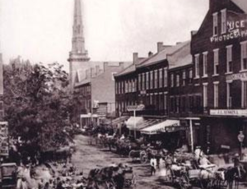
Williamsport, Pennsylvania is a small metropolis with a dramatic history. Famous throughout the world for its impressive forest products, it once boasted more millionaires per capita than any American city.

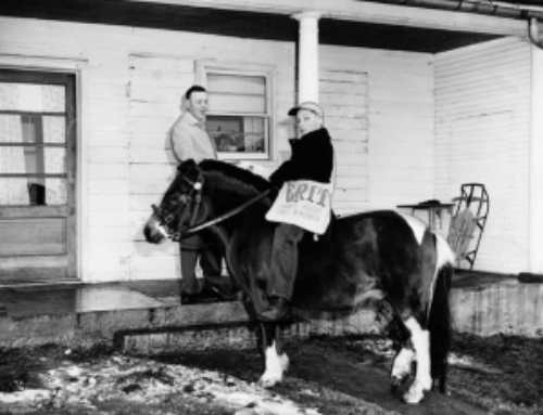
Scott Barn in The Narrows, Lycoming County
A hale and hearty pioneer village on the West Branch of the Susquehanna River, early settlers found it a wild and romantic region with a thriving Indian population. Covered with an abundance of large timber, the virgin forests contained the finest hemlock and white pine. European settlers cut logs for a twofold purpose: to build cabins, and to clear land. After their homes were built, the pioneers looked upon the standing timber as a liability instead of an asset.
Many miles of forest were burned as the land was cleared. Soon, however, the need for finished lumber arose and the first sawmills were erected. Booms were built to divert the logs down the river as a developing New World clamored for sawed timber. Williamsport, the lumber capital of the continent, was more than willing to provide.
From 1862 to 1894, lumber was “King.” At the peak of the era, more than one and one-half million logs were cut from the mountain slopes annually. Transportation evolved from rafts to canal boats, which soon were replaced by the railroad. Williamsport thrived and industry grew. Inevitably, the mountainsides were denuded, forest fires ran unchecked, and disastrous floods toppled the lumbering companies. Its heyday over, Williamsport declined and the inhabitants used the cleared land for agriculture.
The Frontier
Before the coming of European traders and settlers, Indians skillfully managed the natural bounty of the Susquehanna River region by living in accordance with the seasons. They hunted, fished, gathered nuts, berries, and other wild foods, and they cultivated corn, beans, and squash. When discovered by Europeans, Indian groups reflected a Stone Age background, especially in material arts and crafts inhabited Pennsylvania. Tools, weapons and household equipment were made from stone, wood and bark.
Transportation was on foot or by canoe. Houses were made of bark. Clothing came from the skins of animals. The rudiments of a more complex civilization were at hand in the arts of weaving, pottery and agriculture, although hunting and food gathering prevailed. Under the pressure of white settlement, they began to drift westward to the Wyoming Valley, to the Allegheny and, finally, to eastern Ohio.
New World history — and especially that of the Susquehanna Valley — is filled with tales of “rugged pioneers” and “bloodthirsty savages,” and one of the more interesting is Madam Montour. Reliable details of her life are sketchy, but are mythic in proportion. Elizabeth Catherine “Madam” Montour is one of those myths, having led an adventurous life on the French and English frontiers. She was born in 1667 at Three Rivers, Canada, the daughter of Frenchman Pierre Couc and his Algonkian wife (name unknown).
Madam Montour spent several years in the early 1700s at Forts Mackinac and Detroit, Michigan, where her relatives were engaged in the Indian trade. Because of her knowledge of various European and Indian languages, she was employed by Gov. Robert Hunter as an interpreter. There, she married an Oneida chief, Carondowana.
According to historians, she stands out in American history as a “self-fashioned woman . . . the most creative — most outrageous — in fashioning her life from the whole cloth in the midst of Pennsylvania’s most volatile frontiers.”Madam Montour lived near present-day Montoursville with her son, Andrew, and her niece, French Margaret. Her village, Otstonwakin, was essentially a Delaware (Lenape) town. Established around 1728, the village was deserted by 1755, the villagers suffering from a smallpox epidemic.
Another “giant” in early Lycoming County history was Samuel Wallis, probably the largest landholder in the area during the 18th century. According to 19th century historian John Meginness, Wallis was “the most energetic, ambitious, persistent, and untiring land speculator who ever lived in Lycoming County. His energy was marvelous, and his desire to acquire land became a mania which followed him to the close of his life.”
Among those great holdings, Wallis used 7,000 acres near Muncy to locate his estate anchored by a solidly built stone mansion. It was built in 1769 on the high ground near the mouth of Carpenter’s Run.
According to historian Carl Van Doren’s book, “The Secret History of the American Revolution,” published in 1941, Wallis might have played a large part in one of the most notorious cases of perfidy in American history. Van Doren claims Wallis acted as an intermediary in transferring money between British General Sir Henry Clinton and American General Benedict Arnold in a treasonous plot to turn over the fort at West Point, New York, to the British. It has been said that all great men have feet of clay.
Wallis is no exception. He seems to have had a dual quality: that of a great achiever and that of an infamous schemer, but it is unmistakable that he showed great humanity in granting refuge and comfort to those seeking safety from the “Great Runaway,” a time of conflict and bloodshed between the pioneers and the Native Americans. History is filled with rags-to-riches stories of great achievers and great personages, and local history is no exception.
Michael Ross, the founder of the City of Williamsport, is one of those stories. Ross was born July 12, 1759, of Scottish origin. He and his mother came to Philadelphia about 1772, and the two became indentured servants to land speculator Samuel Wallis. Wallis brought them to his estate near Muncy. During his servitude, Ross became a surveyor’s assistant, a skill that would serve him well. He must have made a favorable impression on Wallis during his period of servitude because, at the conclusion of it in 1779, Wallis gave him a favorable recommendation and 109 acres of land. Ross became a successful surveyor and farmed on a large scale. He acquired various tracts of land and added to his acquisitions until he owned plots on both sides of the West Branch of the Susquehanna River.
In 1793, Ross bought 285 acres of land from William Winter. It was that tract of land that later became present-day downtown Williamsport. Meginness writes in his “History of Lycoming County” (1892), “The original plot of land was a rectangular figure containing 111 acres and divided into 302 lots with streets and alleys crossing each other at right angles.” Ross set aside some of the plots for use, such as a courthouse and jail, at the behest of William Hepburn, a strategic step in the decision to locate the county seat in the newly created Lycoming County in 1796. Thomas Lloyd’s “History of Lycoming County” notes that Ross sold the first lots in what would become Williamsport on July 4, 1796.
Ross figures prominently in the naming of Williamsport. Various contentions have been made about the origin of the name, and some assert that it was named for William Hepburn. Others contend it was named for a surveyor friend of Ross by the name of Joseph Williams. A more valid claim is that Ross named the town for his beloved son, William. In April 1976 a Ross descendent, Mabelle J. Schuster of Orange, New Jersey presented a leather-bound diary to the Lycoming County Historical Society. The book contains a page with the entry, “I name the borough of Williamsport for my son William, born on Jan. 22, 1795.” Ross died June 20, 1819. He was buried at the Pine Street cemetery, at the present site of the old City Hall, and was later re-interred at the Williamsport Cemetery on Washington Boulevard.
If Ross is noted as the founder of Williamsport, Hepburn can be regarded as the “Father of Lycoming County,” as firmly a part of the genesis of the county as Ross is of the city. Hepburn was born in Donegal, Ireland, in 1753 and came to America in 1773 or 1774. Following the American Revolution, Hepburn bought a tract of 300 acres known as “Deer Park” within the limits of present-day Williamsport. He became a farmer, a distiller, a merchant and, later, a justice of the peace. Hepburn was elected state senator representing Luzerne, Mifflin, and Northumberland counties in January 1794. During his senate tenure, he played a critical role in the creation of Lycoming County, which was to be carved from territory taken from Northumberland County.
In addition to Williamsport, Lycoming County consists of a number of important municipalities.
The Borough of Jersey Shore resulted from territory taken from six land surveys in 1785. The first settler in what is now Jersey Shore was Reuben Manning, who located his home on a tract of land owned by his nephew, Thomas Forster. Manning and Forster were both from Essex County, New Jersey. As the settlement grew, it became known as “Jersey Shore” because of Manning’s and Forster’s New Jersey origins, a name used derisively by early Irish settlers there. In 1805, the area was called “Waynesburg,” but it never stuck. When the settlement was incorporated as a borough March 15, 1826, the incorporation document read, “the place shall be called and styled the borough of Jersey Shore.”
Several miles northeast of Jersey Shore, along the mouth of Larrys Creek, lies the borough of Salladasburg. Captain Jacob Sallade founded it in 1837 when he laid lots in the town and built Lutheran and Presbyterian churches. Sallade also built the first gristmill for the town. A tannery, owned by Robert McCullough, was the leading industry in the early years of Salladasburg. It was incorporated as a borough in 1884, with the slight difference in spelling. Armstrong is the only township in Lycoming County that has had two boroughs carved from it.
DuBoistown was the first of the two boroughs established. Located at the mouth of Mosquito Creek, it is a on tract of land once owned by Samuel Boone, brother of Hawkins Boone, a martyred Indian fighter and cousin of the famous Daniel Boone. Andrew Culbertson owned 172 acres adjoining Boone’s property, and established a gristmill, sawmill and a home for his family within the boundaries of present-day DuBoistown, where a small town developed. In 1856, John DuBois purchased land within the boundaries of the area and laid out a town that he christened “DuBoistown.” Thirty years later, he founded another town, this time in Clearfield County, which he just called “DuBois.” DuBoistown was incorporated as a borough Oct. 14, 1878, despite opposition from residents of Armstrong Township.
The original settlers of the area that now is South Williamsport were Germans who settled near Hagerman’s Run. The area around the Market Street Bridge once was known as “Rocktown” because of the rocky soil found there. Another section of present-day South Williamsport was called “Bootstown,” named for a nearby man who stole a pair of boots. Jacob Weise bought forty acres within the boundaries of South Williamsport and laid it out in town lots, starting South Williamsport on the road to an organized town, as the South Williamsport Land Co. was organized. Again, with some opposition from citizens from Armstrong Township, South Williamsport was incorporated as a borough November 29, 1886. According to John F. Meginness’ “History of Lycoming County,” the first white man to settle in the area that became Hughesville was David Aspen in 1777. He fled the next year during the “Great Runaway.”
The land where present-day Hughesville is located was sold to John Heap on May 7, 1793, and he in turn sold it to Samuel Harrold, who conveyed it to his son John. Jeptha Hughes bought the land from Harrold on March 23, 1816, and he laid out a town and named it “Hughesburg,” but it was later changed to “Hughesville.” In July 1820, Hughes sold the entire plot of land to Daniel Harrold. Paul Willey opened the first tavern there in 1820, and the first post office was established in 1827.
Hughesville was incorporated as a borough on April 23, 1852. About two and one-half miles north of Hughesville lies the borough of Picture Rocks. Nearby, a ledge of rocks rises from the bank of the Big Muncy Creek to a height of more than 200 feet. The first settlers there found a number of Indian pictures painted on the rocks, but the pictures have long since disappeared, and nobody ever translated the Indian hieroglyphics. Legend has it that the flat area below the rocks was once a favorite camping spot for the Monsey Indians. A.R. Sprout and Amos Burrows founded the town in the fall of 1848, and some of their descendants still live there.
The first post office was established in Picture Rocks in 1861, and the borough was incorporated on September 27, 1875. One story illustrates the determined character of the early residents of Picture Rocks. Churchgoers met in an old, dilapidated schoolhouse, and a circuit preacher once remarked to one of the members of the church that he “dreaded attempting to preach in that pig pen of a house with such low ceilings and the broken walls.” So the people of Picture Rocks acquired a lot, and through their combined labor and material, the erected a sturdy church in just eight days, one that served them well for more than twenty-five years.
According to historian Meginness, “There is much bold and beautiful scenery in easy view of Montgomery,” and it continues to be one of Montgomery’s major assets. Cornelius Low was probably the first settler in 1778 in the area, with John Lawson and Nicholas Shaffer soon following him. A town grew slowly and a post office, “Black Hole” with Samuel Ranck as its first postmaster, was established March 26, 1836. In 1853 “Black Hole” became “Clinton Mills” and in 1860 it became “Montgomery Station.” The borough of Montgomery was built on land taken from Clinton Township, and Montgomery became a borough on March 27, 1887.
The area of Muncy was one the earliest places to be settled in the West Branch Valley, surveyed by John Penn in 1769. Four brothers, Silas, William, Benjamin, and Issac McCarty settled the area in 1787 and bought lots. In 1797, Benjamin McCarty laid out the town that he named “Pennsborough.” The town grew slowly and was just a sleepy little village, earning the nickname of “Hardscrable.”The first post office was established in April 1801.
Pennsborough was incorporated as a borough on March 15, 1826. On January 19, 1827, the name was changed to Muncy because many people thought that the previous name was “too flat and too long.” The new name would be more in keeping with the historical nature of the place and also would help to perpetuate the name of the Indians who used to reside in the area. The name of “Muncy” is derived from the Monsey Indians, a tribe of Delaware Indians living there. The Indians were eventually driven out and settled in another area that eventually became named for them: Muncie, Indiana.
By Robin Van Auken and Lou Hunsinger Jr.
Williamsport Firsts
By Lou Hunsinger Jr. Williamsport Sun-Gazette
According to historians, when founder Michael Ross surveyed the 111 acres that became Williamsport, he could not have imagined that his small community would grow from a one-building village to the county seat of Lycoming. During its first 100 years, the region experienced quite a few “memorable firsts.” They include:
- The first white man to enter the region is believed to have been Frenchman Etienne Brule. He left Canada in 1615 to help secure territory for New France. He was taken captive by Indians near present-day Muncy and later escaped.
- The first houses were three, rude log cabins built in 1761 on clearings owned by Bowyer Brooks, Robert Roberts and James Alexander in present-day Muncy.
- The first grist mill was erected by John Alward in 1772 on Muncy Creek, just west of the Muncy hills.
- The first fatal hunting accident occurred in 1769, when Joseph Jacob Wallis, half brother of Samuel Wallis, land speculator and one of the county’s earliest distinguished citizens, mistook William Beaver for a bear along Muncy Creek.
- Probably the first person buried in what became a formal cemetery was the same unfortunate William Beaver, who was buried in what became Hall’s Cemetery.
- According to John F. Meginness’ “History of Lycoming County,” “To the borough of Muncy goes the credit of having the first habitations erected by white men upon her site in Lycoming County.”
- The first white person born west of Muncy Hills was Mary Scudder on May 21, 1771. Her mother, Susan, was the first woman to settle in Lycoming County. She and her husband, John, came to the area from New Jersey.
- The first white male born west of the Muncy Hills was John Lukens Wallis, son of Joseph Jacob Wallis, in 1773.
- The first public road through Lycoming County was constructed about 1775. It followed Indian trails along the Susquehanna River between Fort Augusta (Sunbury) and the mouth of Bald Eagle Creek (Lock Haven).
- The first practicing physician in the county was Dr. Benjamin Allison. As early as 1777, he was paid to tend to members of the militia wounded by Indians and Tories.
- The first name considered for this county was Jefferson. Susquehanna and Muncy also were considered and rejected in favor of Lycoming, after the stream long known as the bloody edge of disputed Indian territory.
- In the first election in Lycoming County on Oct. 16, 1795, Samuel Stewart was elected the county’s first sheriff and John Hanna, Thomas Forster and James Crawford were elected the first county commissioners.
- The first person to represent Lycoming County in the U. S. Congress was Andrew Gregg. He served until 1807. William Hepburn was the first to represent the county in the state senate.
- The first county representatives in the state house were Flavel Roan, Hugh White and Robert Martin.
- The first house to be built in Williamsport also was its first inn. It was built by James Russell of logs in 1786 at the northeast corner of East Third and Mulberry streets.
- James Russell, son of William Russell, was recorded as the first person born in Williamsport in 1796.
- The first church erected in the county was the Newberry Presbyterian, now Lycoming Presbyterian Church on Arch Street. The date of construction is unknown but it is said to have existed as early as 1786, and there is evidence that Presbyterian services were held along Lycoming Creek as early as 1746.
- The first sawmill in the county was built four miles up Lycoming Creek by Roland Hall in 1792.
- The first brewery was established in 1854 by a Mr. Huffman, who sold it in 1865 to Henry Jacob Flock. The Flock Brewery operated into the 1940s.
- In 1796, the first schoolhouse was built of logs in the area to the rear of what became the county courthouse. Its first schoolmaster was Caleb Bailey.
- The first post office opened in 1799 at the corner of Third and State Streets in Williamsport. It later became a saloon.
- The first store in Williamsport was opened in 1801 by William Winter at the corner of Third Street and South Alley.
- Henry Lenhart opened the first drug store in Williamsport in 1815 at the southeast corner of Third and Pine streets.
- The first train came through the county in 1839 when a railroad connecting Williamsport and Ralston opened along Lycoming Creek.
- The county built the first bridges across Loyalsock and Lycoming creeks in 1822 and 1823. Both were timber-arch structures.
- The first bridge over the river at Williamsport was a toll bridge that opened in 1849. It was built at Market Street by the state at a cost of $23,797.
- H.R. Rhoads owned the first telephone in Williamsport in 1879. The first telephone exchange opened on May 1, 1879 with 25 subscribers. Williamsport’s was the second telephone exchange established in the state of Pennsylvania after Erie.
- The first cemetery established specifically to be a cemetery was on the site of the present-day Calvary United Methodist Church and also the site of the Plum Thicket Massacre of June 10, 1778. Victims of that massacre were interred there for a time.


