

Ricketts Glen State Park
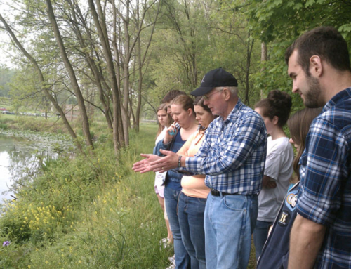
 Ricketts Glen State Park in Benton, PA, is a haul up to the top of a mountain, but it’s worth it!
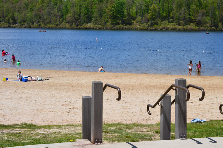
According to the Pennsylvania Department of Conservation and Natural Resources, “Ricketts Glen harbors Glens Natural Area, a National Natural Landmark. Take the Falls Trail and explore the Glens, which boasts a series of wild, free-flowing waterfalls, each cascading through rock-strewn clefts in this ancient hillside. The 94-foot Ganoga Falls is the highest of 22 named waterfalls. Old growth timber and diverse wildlife add to the scenic area. Ricketts Glen State Park is one of the most scenic areas in Pennsylvania. This large park is comprised of 13,050 acres in Luzerne, Sullivan and Columbia counties.” We spent the afternoon at the park during it’s busiest time of the year: Memorial Day Weekend. Hundreds of people of all ages gathered at the park to enjoy sunshine, swimming, kayaking, canoeing, camping and hiking.
Here are specs on Ricketts Glen State Park from the DCNR website:
Picnicking: Picnic facilities are located in the Lake Jean area and in the lower area off PA 118. A limited number of charcoal grills and hot charcoal disposals are located in the picnic areas. Two picnic pavilions may be reserved up to 11 months in advance for a fee. Unreserved pavilions are available on a first-come, first-served basis.
Make a reservation.
Swimming: The 600-foot beach is open from late-May to mid-September, 8 a.m. to sunset. Swim at your own risk. Please follow posted rules and regulations. A food and refreshment concession, boat rental and picnic facilities are nearby.
Swimming is permitted inside of the designated area only.
Food and Refreshment Concession: The snackbar is in the park’s Beach Area. The concession can be accessed by Parking Lot 1 or Parking Lot 2 off of Main Park Road off of PA 487, 3.7-miles north of the town of Red Rock. The concession serves a variety of hot sandwiches along with cold and hot beverages and ice cream. Other items include candy, snack food, and ice. The concession is open (weather permitting) from Memorial Day through Labor day, 7-days per week from 11 a.m. to 5 p.m.
Boating: electric motors only The 245-acre Lake Jean has dry mooring and two boat launches. A boat rental concession operates during the summer season and offers rowboats, paddleboats, kayaks and canoes.
Motorboats must display a current boat registration. Non-powered boats must display one of the following: boat registration; launching permit or mooring permit from Pennsylvania State Parks, available at most state park offices; launching permit from the Pennsylvania Fish and Boat Commission.
Complete information on boating rules and regulations in Pennsylvania is available from the Pennsylvania Fish and Boat Commission Web site.
Fishing: The 245-acre Lake Jean has warm-water game fish, panfish and trout. Please follow all Pennsylvania Fish and Boat Commission rules and regulations. Fishing is prohibited in the Glens Natural Area.
Complete information on fishing rules and regulations in Pennsylvania is available from the Pennsylvania Fish and Boat Commission Web site.
 Hunting and Firearms: About 10,144 acres are open to hunting, trapping and the training of dogs during established seasons. Common game species are deer, turkey, grouse, bear, coyote, pheasant and squirrel. Common furbearers are raccoon, mink, muskrat, beaver, coyote and bobcat. About 83,000 acres of state game lands lie to the west and north of the park.
Hunting woodchucks, also known as groundhogs, is prohibited. Dog training is only permitted from the day following Labor Day through March 31 in designated hunting areas. The Department of Conservation and Natural Resources and the Pennsylvania Game Commission rules and regulations apply. Contact the park office for ADA accessible hunting information.
Use extreme caution with firearms at all times. Other visitors use the park during hunting seasons. Firearms and archery equipment used for hunting may be uncased and ready for use only in authorized hunting areas during hunting seasons. In areas not open to hunting or during non-hunting seasons, firearms and archery equipment shall be kept in the owner’s car, trailer or leased campsite. Exceptions include: law enforcement officers and individuals with a valid Pennsylvania License to Carry Firearms are authorized to carry a firearm concealed on their person while they are within a state park.
Complete information on hunting rules and regulations in Pennsylvania is available from the Pennsylvania Game Commission Web site.
Hiking: 26 miles of trails Trails vary from fairly level to very steep hills. The 26 miles of trails are a prime attraction of the park.
CAUTION: Hikers on the Falls Trail should be in good physical condition, wear sturdy boots, and use caution due to slippery/wet conditions and steep trail sections.
The following guidelines will help ensure a safe and enjoyable hiking experience while at the park.
- Always wear sturdy boots. Wearing sneakers, sandals, “water shoes” and “street shoes” can lead to serious accidents in this park.
- Be prepared. Have proper clothing and equipment (i.e. compass, map, matches, water, food, flashlight, etc.) available in case of an emergency. This is especially important when traveling remote trails or when hiking during non-summer seasons.
- Give yourself plenty of time for your hike. The weather changes quickly in the park. Plan to be off the trails well before dark.
- Let someone know where you are hiking and when you should return.
- Stay on the trails. Leaving the trail causes damage to unique natural resources, promotes erosion and can be dangerous.
- Don’t take short cuts from one trail section to another. Taking short cuts down switchbacks is dangerous and causes trail damage.
- Double blazes indicate a change in the trail’s direction.
Falls Trail: 7.2 miles, most difficult hiking The full loop of this trail is 7.2 miles if hiking both the upper and lower sections. To see most of the waterfalls, a 3.2-mile loop can be taken by going on Highland Trail and the Glen Leigh and Ganoga Glen sides of the trail. The trails follow along 21 beautiful waterfalls ranging in heights from 11 feet to 94 feet. The scenery is well worth the effort, however, the terrain is rocky, can be slippery, and descends steeply on both the Ganoga and Glen Leigh sides. Hikers should take extra precautions with trail conditions, wear proper footwear, stay on the trail, and be in good physical condition.
The Falls Trail is closed in the winter except for properly equipped ice climbers and hikers.
Beach Trail: 0.8-mile, easiest hiking Campers in both camping areas can access the Lake Jean day-use and swimming areas without having to travel on a road.
Cherry Run Trail: 4.6 miles, more difficult hiking Near the Lake Leigh dam is access to Cherry Run Trail, where hikers will pass through groves of cherry trees and view evidence of the old logging railroads that passed through this area over 100 years ago. Hikers can connect to Mountain Springs Trail by walking 3.5-miles on Mountain Springs Road.
Evergreen Trail: 1 mile, easiest hiking Self-guiding tours take visitors into old growth forest, one of the few stands remaining in all of Pennsylvania. Hikers can see a hemlock that stood on this continent before Columbus. This is an easy, 1 mile hike into the past.
Ganoga View Trail: 2.8 miles, more difficult hiking Named after the park’s highest waterfall, this trail allows hikers to walk up to the side of Ganoga Falls without having to hike the Falls Trail. Although the trail is easy to moderate hiking, use caution where it meets Falls Trail due to the switchbacks and drop-offs. Ganoga View along with the Old Beaver Dam Road Trail makes an excellent loop trail for hikers and cross-country skiers.
Grand View Trail: 1.9-miles, more difficult hiking This trail takes hikers to the highest point on Red Rock Mountain (elevation 2,449 ft). In mid-June, the beautiful mountain laurel is in bloom. The best view is during the limited time that the fire tower is open (fire season in the spring and fall). In mid-July, the high bush blueberries bear fruit, and in the fall, there are awe inspiring views of the fall foliage encompassing the surrounding hillsides, making this trail a pleasant hike at any time of the year.
Highland Trail: 1.2-miles, more difficult hiking The trail cuts across the top of the Falls Trail and crosses through Midway Crevasse, a narrow passageway between large blocks of Pocono sandstone conglomerates that were deposited throughout this area by glacial movements. At least three times in the last one million years, continental glaciers buried this land under hundreds of feet of ice. This trail makes an excellent area for geological study groups.
Mountain Springs Trail: 4 miles, more difficult hiking Heading off of the beaten path, this trail takes hikers on a 4-mile hike passed the old Lake Leigh Dam, the forgotten falls, and down the south branch of Bowmans Creek to the serene Mountain Springs Lake area. Hikers can connect to Cherry Run Trail by walking 3.5-miles on Mountain Springs Road.
Old Beaver Dam Road Trail: 1.2-miles, more difficult hiking Named for the old beaver dam that can be seen just off the trail, this trail makes an excellent loop trail for hikers and cross-country skiers. Access is from a small pull-off of PA 487, or from the Lake Rose parking lot.
Old Bulldozer Road Trail: 2.9 miles, most difficult hiking With its unique name (once used by a bulldozer to get to the top of the mountain to build the park), comes quite an elevation change. Accessed from the parking lot on PA 118, this trail is used by hikers and snowmobilers to access Mountain Springs Trail. Although most of the trail is easy to moderate hiking, a short section just up from the bottom is very steep.
The Bear Walk Trail: 1 mile, easiest hiking Walk the trail of the bears – this short trail accesses other trails for cross-country skiing, snowmobiling and hiking. It runs from the entrance of the cabin area to Lake Rose.
Horseback Riding: 12.5-mile loop Horse riders may enjoy taking a 12.5-mile loop by riding the Cherry Run Trail, Fish Commission Road, and Mountain Springs Trail. Sights to see include: old railroad grades, Mountain Springs Lake (formerly used to make ice), and an old concrete dam once used to hold back Lake Leigh (now a dry lake). Riders must bring their own mounts. Horses cannot be rented.
Stay the Night
Camping: flush toilets, warm showers There are 120 tent and trailer campsites, some available year-round. The campground features hot showers, flush toilets, shaded sites, gravel parking spurs and a sanitary dump station. Six campsites are ADA accessible. Pets are permitted on designated sites.
Explore the campground map.
Explore camping for more information.
Make a reservation.
Free Camping for Campground Hosts: one host position The modern campground host site has amenities that include 200-amp electric service and water hookup (septic is not on site, but a dump station is available). A long-term stay from April through October is preferred, but not required. The host is required to assist park personnel inspect buildings, light cleanup, greet people, litter pick-up, light maintenance and fire ring cleaning. Contact the park office for additional information and availability.
Modern Cabins: Ten modern rental cabins are available year-round. Cabins are furnished and have a living area, kitchen/dining area, toilet/shower room and two or three bedrooms. Cabin F is ADA accessible. Linens and dishes are not provided.
Explore the cabin map.
Explore cabins for more information.
Make a reservation.
Organized Group Tenting: Qualified adult and youth groups may use this 240-person capacity area that is equipped with picnic tables, water and flush toilets. The area is open from the third Monday in April to the third Monday in October. Advance reservations are recommended.
Explore organized group tenting for more information.
Winter Activities
Explore the Winter Report for the current snow and ice depths.
Cross-country Skiing: Hiking trails may be skiied when snow cover permits.
Snowmobiling: Many trails allow snowmobiles after the end of deer hunting when conditions permit.
Ice Fishing: Lake Jean offers ice fishing. Ice thickness is not monitored. Be sure the ice is at least four inches thick and carry safety equipment.
Environmental Education and Interpretation
Natural wetlands, old growth forests and majestic geological formations, which helped produce 22 beautiful waterfalls, make Ricketts Glen an excellent choice for outdoor studies. From March to November, the environmental education specialist conducts hands-on activities, guided walks and presentations on the natural and historical resources for school groups, scouts, civic organizations and the general public. Call in advance to set up a program that will enhance your classroom or group studies. Campers and visitors may check the bulletin boards and at the park office for listings of weekend programs and nature hikes.
Explore the Calendar of Events for a listing of events from today forward.
Explore environmental education and interpretation for more information.
Access for People with Disabilities
If you need an accommodation to participate in park activities due to a disability, please contact the park you plan to visit.
How to Access the Waterfalls
Twenty-one waterfalls are along the Falls Trail within the Glens Natural Area, while one (Adams) is only a few hundred feet from the Evergreen Parking Lot off PA 118. There are three parking lots that provide access to the Falls Trail. Lake Rose is at the end of the dirt road across from the campground and provides the closest access (5-10 minutes), but fills up quickly during peak times. An alternative is to park in Beach Parking Lot #2, leave the lot and walk down the Cabin Road (first road just outside of the lot), past a park gate, and onto a section of trail to the first intersection where you go right (15-20 minute access). The parking lots on PA 118 are 1.5 miles from the first waterfall upstream on the Falls Trail, but allow a good view of old growth trees. The full loop of the Falls Trail is 7.2 miles if hiking both the upper and lower sections. To see most of the waterfalls, a 3.2-mile loop can be taken by going on Highland Trail and the Glen Leigh and Ganoga Glen sides of the trail.
Ready for a Challenge?

Have even more fun when you accept the 21-Day Writing Sprint Challenge. This process is one I use every semester with my college students, so I know it can kickstart your creativity and introduce structure to your writing schedule. When you join my Circle of Writers & Authors, you’ll receive FREE writing resources, and you’ll sign up for my newsletter. I will not sell your information, or spam you. I will send you updates about new articles and podcasts I’ve created, and projects I’m working on. You can unsubscribe at anytime. Read my Privacy Policy here.
Wholehearted Author is for you if you are …
- Starting out as a writer and could use some guidance
- Wanting to be inspired to create and publish your book
- Looking for like-minded, happy people and helpful mentors
- Hoping to turn your writing into a full-time, awesome career
- New to the concept of “permission marketing” but willing to try

CATCH THE WEST WIND
Add WEST WIND to your library!
If you love a good mystery, a romantic whodunit that will surprise you, then WEST WIND is a great addition to your ebook library.
West Wind is my third novel as an author of Contemporary Fiction, Suspense, Thriller, and Romance. It’s FREE too, when you join my exclusive Readers Group. Join today and download your free book, and as a special thank you, you’ll receive a SECOND FREE BOOK tomorrow! The giving goes on and on when you become my fan.
When you join my Readers Group, you’ll receive updates about new projects I’m working on. You can unsubscribe at anytime. Read my Privacy Policy here.


